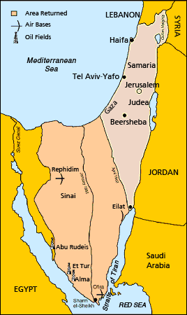
This map describes the implementation of the Egypt-Israel Peace Treaty in 1982. That treaty expressly established “secure and recognized boundaries” under UN Resolution 242 in the context of peaceful relations with Egypt. The demarcation lines of 1949 are not shown, as they were no longer legally applicable after the armistice ended in 1967, although those lines were treated as an informal “green line”. Land beyond the green line continued to be governed by Israel as “the Territories”, pending the negotiation of a similar peace with the Palestinians.
NB: There are important reasons why the government of Israel does not show the boundaries of the land administered by the Palestinian Authority on its official maps. The basic reason is that the boundaries of a future Palestinian state are being negotiated in the “final status negotiations” under the Oslo Accords, which provide that the position of “borders” will be part of a final peace agreement, which has not yet been achieved. There are therefore no lines which can yet be drawn on a map.
The same principle follows from UN Resolution 242, which provides that in any peace agreement Israel will withdraw to “secure and recognised boundaries”. On this basis the peace treaties with Egypt and Jordan provide that the borders fixed by the treaties are “secure and recognised boundaries”. When there is a peace treaty concluded by the Palestinian Authority this will hopefully include the same provision.
